Badrinath Route Map Guide (2026) – Complete Detailed Travel Route, Distance, Stops & Planning

Introduction – Understanding the Route to Badrinath

The journey to Badrinath Temple is one of the most scenic and spiritually enriching routes in India. Unlike Kedarnath, Badrinath is fully accessible by road, making it a popular destination for families, senior citizens, and pilgrims of all ages.

Starting from Haridwar or Rishikesh, the route takes you through river valleys, mountain roads, and sacred confluences known as Prayags.
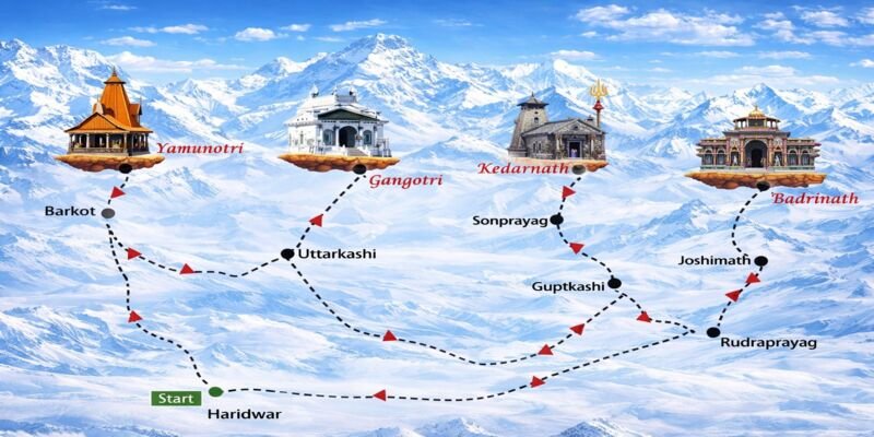
πŸ‘‰ This guide explains the complete route map, distance, key stops, and travel strategy in detail.


πŸ“ Total Distance & Travel Overview


πŸ“Š Key Information:

  • Distance from Haridwar: ~320 km
  • Distance from Rishikesh: ~295 km
  • Travel Time: 10–12 hours
  • Route Type: Mountain road (fully motorable)

🧭 Route Flow:

Haridwar β†’ Rishikesh β†’ Devprayag β†’ Srinagar β†’ Rudraprayag β†’ Karnaprayag β†’ Nandprayag β†’ Joshimath β†’ Badrinath


πŸ‘‰ This route follows the Alaknanda River, making it both scenic and spiritually significant.


πŸ—ΊοΈ Step-by-Step Route Map Explained


🟒 1. Haridwar β†’ Rishikesh (25 km)

  • Time: 45–60 minutes
  • Road: Smooth and wide

What Happens Here:

This is the starting stretch where you leave the plains and move toward the Himalayan foothills.


Why It Matters:

  • Last major city with full facilities
  • Ideal for final preparation

🟒 2. Rishikesh β†’ Devprayag (75 km)


πŸ“Έ Devprayag Confluencehttps://images.openai.com/static-rsc-3/tnSaXzvJN-6hVVnXIotp-c0ZgJAmur0Pn6btWJpX_T41JlaWz_FnTG-BEMuH0N3ZP2YdaEjm6_YXnd1u2ekeaf1O0bw_4s5egDiD-4o13Qc?purpose=fullsize&v=1


  • Time: 3–4 hours
  • Terrain: Narrow, winding mountain roads

Importance:

Devprayag is where:
πŸ‘‰ Ganga River officially begins


Travel Insight:

  • Roads become curvy
  • Drive slowly
  • Take breaks

🟒 3. Devprayag β†’ Srinagar (35 km)

  • Time: 1–1.5 hours

Why Stop Here:

  • Fuel stations
  • Restaurants
  • Rest point

🟒 4. Srinagar β†’ Rudraprayag (33 km)

  • Time: 1–1.5 hours

Key Highlight:

Rudraprayag is the confluence of:
πŸ‘‰ Alaknanda + Mandakini rivers


Travel Note:

  • Scenic but narrow roads
  • Increasing altitude

🟒 5. Rudraprayag β†’ Karnaprayag (31 km)


πŸ“ Karnaprayag Importance:

  • Confluence of Alaknanda & Pindar rivers
  • Important spiritual stop

Travel Experience:

  • Smooth yet winding roads
  • Beautiful valley views

🟒 6. Karnaprayag β†’ Nandprayag (21 km)

  • Short distance
  • Scenic route

Significance:

  • Another sacred confluence point

🟒 7. Nandprayag β†’ Joshimath (70 km)


πŸ“Έ Joshimath Route

https://images.openai.com/static-rsc-3/hMAZKX-EatnzmvCy9xPr4TUxFkdZ31KTtNpF4S_8vCw8U3bN9BkJgnP4VWf5LhoRklhLb2iT7HY7r2ploIALiAuTjptnKoSiMeGjN123Go4?purpose=fullsize&v=1
 

  • Time: 3–4 hours

Why Joshimath is Important:

  • Major base town
  • Hotels and medical facilities
  • Winter seat of Badrinath

πŸ‘‰ Most travelers stay overnight here.


🟒 8. Joshimath β†’ Badrinath (45 km)


πŸ“Έ Final Stretch to Badrinath

https://www.travelride.in/assets/trblogs/blg11.jpg
 

  • Time: 2–3 hours

What Makes This Stretch Special:

  • High altitude
  • Snow peaks visible
  • Narrow roads

πŸ‘‰ This is the most beautiful part of the journey.


πŸ“Š Distance Summary Table

SegmentDistance
Haridwar β†’ Rishikesh25 km
Rishikesh β†’ Devprayag75 km
Devprayag β†’ Srinagar35 km
Srinagar β†’ Rudraprayag33 km
Rudraprayag β†’ Karnaprayag31 km
Karnaprayag β†’ Nandprayag21 km
Nandprayag β†’ Joshimath70 km
Joshimath β†’ Badrinath45 km

πŸ—“οΈ Suggested 3–4 Day Itinerary


Day 1:

Haridwar β†’ Joshimath


Day 2:

Joshimath β†’ Badrinath β†’ Darshan


Day 3:

Return journey


πŸ‘‰ For relaxed travel, extend to 4 days.


🚘 Travel Options Explained


πŸš— Private Car

  • Best option
  • Flexible stops

🚌 Bus

  • Budget-friendly
  • Less flexible

🚁 Helicopter

  • Fastest option
  • Premium travel

🌀️ Best Time to Travel


βœ”οΈ May – June β†’ Comfortable
βœ”οΈ September – October β†’ Scenic


❌ Avoid:

  • Monsoon
  • Winter

⚠️ Important Travel Tips


Road Safety:

  • Avoid night driving
  • Drive carefully on curves

Health:

  • Carry medicines
  • Stay hydrated

Planning:

  • Book hotels in advance
  • Start early each day

🧠 Practical Ground Reality


  • Roads are narrow after Rudraprayag
  • Traffic can be heavy
  • Network is limited
  • Weather unpredictable

πŸ‘‰ Always stay flexible.


❓ Frequently Asked Questions


How far is Badrinath from Haridwar?

Around 320 km.


Is road fully accessible?

Yes, no trekking required.


How many days are needed?

2–4 days.


Is route safe?

Yes, with careful driving.


Which is best stop for stay?

Joshimath.


🏁 Conclusion – A Journey of Scenic Beauty & Spiritual Depth

The route to Badrinath is one of the most beautiful road journeys in India. Unlike many other Himalayan destinations, it combines accessibility with deep spiritual significance.

From the sacred confluences of Devprayag and Rudraprayag to the breathtaking high-altitude views near Badrinath, every part of the journey offers something unique.

Understanding the route in detail allows you to travel with confidence, manage time effectively, and fully enjoy the experience.

πŸ‘‰ In the end, Badrinath is not just a destinationβ€”it is a journey where every kilometer brings you closer to peace, devotion, and the beauty of the Himalayas.

With proper planning and awareness, your trip becomes smooth, safe, and truly unforgettable